準確預報颱風不是夢!浮標觀颱研究登頂尖期刊
在科技部、臺灣大學、氣象局等多個單位的支持下,由臺灣大學海洋研究所團隊布建的海氣象浮標,收集到史上第一回超級颱風中心沿路掃過的海洋浮標觀測資料,在此一研究領域裡,這是首次完全由臺大團隊、本土人才完成並發表在2019年4月《自然通訊》(Nature Communications)的研究成果,研究成果也將被轉譯成電腦程式語言,植入颱風數值預報模式,朝準確預報颱風邁進一大步。
大約在1970、80年代,科學家即已看出海洋上層的熱水可以孕育出颱風,颱風靠著不斷吸收海面上的熱氣茁壯,而暖水層夠不夠熱、熱能吸收的效益,則似乎取決於颱風眼經過當地海洋前後僅僅10小時內的關鍵期 (稱為風直接影響期),但科學家始終苦於沒有海洋現場的高解析度觀測資料以解析個中道理,也不確定颱風過後溫暖的洋面如何變成冷水坑。這個謎團可說被兩組浮標一舉解密,揭露關鍵時刻大氣和海洋間互動的連續過程。這個重要的跨領域研究成果,不僅展現出基礎科學對於人類認識大自然的貢獻,也同時是另一個,關鍵的研究技術與儀器帶來突破性創新的例子,對於預警天然災害、減少國民生命財產損失,產生重要的貢獻。
研究團隊兩組浮標成功紀錄了2016年超級颱風「尼伯特」來襲時的資料,顯示海水上層溫度在颱風眼到來的4小時內陡降1.5°C,但尼伯特的強度卻未增減,在夜以繼日進行數據分析後,發現了限制颱風成長的機制,原來表層水溫減少1.5°C的熱量,颱風只吸收了一點點;由裝在浮標上的縮時攝影機所拍到史無前例的超級颱風影像和海流儀資料分析,這關鍵的4小時內,海洋上層的熱水雖被狂風、巨浪所激起的水花散到颱風裡,但同時颱風本身又強迫表層海水快速向前衝,上層海流變快了,下層海流跟不上,上下層海水拖拉之間在水裡捲出無數大大小小的漩渦,底下冰冷的海水反而被迅速翻攪上了水面,熱餐頓時成了冷飲,破壞了颱風繼續茁壯的機會,成了名符其實的「吃快弄破碗」。自2015年以來,浮標已記錄到10個颱風經過時的海氣象變化,揭露本限制機制僅是其中一小部分的研究成果。這項「利他」行動的最終目標是要在TOMATO (TOwards Multiple Arrays for Typhoon Observations) 「多平台颱風觀測網」計畫下,建立西北太平洋海氣象浮標和水下滑翔機觀測陣列,捕風捉影守護臺灣,未來亦計畫跟菲律賓氣象單位及大學合作,擴大TOMATO防護網範圍。
準確地預報颱風除了靠我們對海氣交互作用物理機制的認知,也需要關鍵的大氣和海洋現場觀測資料不斷地注入電腦數值模式,時時校驗、修正預報結果。雖然科技的發展加上大量衛星遙測資料,對於颱風路徑的預報已有長足進步,但因對海洋與颱風互動的觀測仍相當缺乏,在颱風強度的預報依然面臨很大的挑戰,尤其如何把握時機在颱風撲台前派研究船到海上「守株待兔」進行觀測或布放測量儀器,無異是老鼠給貓掛鈴鐺,幾乎是「不可能的任務」。但若能事先到選定的海域布放錨碇式的浮標去「堵」颱風,用各種先進的探測儀器自動量測大氣和海洋的關鍵性質,並以最快的速度傳回陸上的實驗室進行預報分析工作,安全又有效。然而,市面上並沒有這種能一邊準確測量海氣性質、一邊又能快速回傳資料的商品化浮標,即使能夠重金購得,也還需要一筆請廠商布放、維護的龐大經費。
為了挑戰這個艱難、近乎不可能的任務,臺大海洋所憑藉數十年養成的研究實力輔以海研一號貴儀中心精良的探測技術,2015年 (莫拉克6年後) 由時任所長的魏慶琳教授集合海洋物理專長的教師和電子、機械、錨碇探測和資訊專長的技術人員組成浮標團隊,善用來自臺大邁頂計畫、科技部和中央氣象局挹注的資源和人力,突破技術瓶頸,拆掉海氣象浮標上的舊品,換裝運用省電科技自力研發之中控系統與即時資料衛星傳輸,連年由楊穎堅副教授領軍於颱風經過最頻繁,而現場觀測資料最缺乏的西北太平洋海域布放此進階版浮標,捕捉颱風肆虐下的海氣象變化,研究狂風猛浪下的海氣交互作用。兩組浮標在2016年成功地挺過超級颱風「尼伯特」颱風眼掃過前後的摧殘,不負眾望地即時傳回現場精準的海氣象實測數據,幫忙我們解析瘋狂海象下,大氣與海洋互動的細膩過程,達成此艱鉅任務中的不可能任務,可謂以小搏大立大功。
浮標計畫成功的背後,隱含許多值得一提的面向。整個浮標任務從科學目標的擬定、設計、製作、測試、施放到資料分析都是由臺灣本土團隊自力完成,以極少的資源獲得極大的成果,為科技深耕的優良典範,也代表科技部自然司長期支持海洋研究及貴重儀器中心的具體成果;臺灣大學海洋研究所成立至今五十年,肩負培養海洋科技人才責任,此篇論文的六位作者有五位是畢業自該所的碩博士,顯示臺灣已有培養海洋科技高階人才的能力;海氣象浮標的應用涵蓋災防、環保、社教與學術研究,甚至在拓展臺灣國際活動空間層面上都能扮演角色,值得政府相關單位關注與支持。
颱風年年侵襲東亞,威脅海岸地帶近10億人口。2009年中颱「莫拉克」橫掃南臺,導致六百多人喪生、超過一千五百億臺幣財損;2013年史上最強超級颱風「海燕」貫穿菲律賓,奪走六千多條人命,造成約六百億臺幣損失。如果當時能更準確預報颱風並及早採取適當防範及避難措施,必能全面減輕災損。
浮標團隊計劃將於今年6月前往西北太平洋布放兩組浮標再戰颱風。颱風、海嘯、氣候變遷預警防災不能靠喊口號,決戰第一線也不在陸上,讓海上浮標成為護衛臺灣的前哨!
Ocean buoys reveal the evolution of typhoons, which helps typhoon disaster mitigation
Two functional-improved data buoys, designed, assembled and deployed by a marine research and technical team at National Taiwan University (NTU), survived from fierce wind and sea state of Super Typhoon Nepartak (Category 5) in the western North Pacific, and successfully recorded crucial air and sea variables within a few kilometers from the center of Nepartak. The unprecedented dataset provides new insights into the air-sea interaction during extremely strong typhoon wind and reveal the evolving processes of typhoon’s strength, which is recently published in Nature Communications. This down-to-earth accomplishment is solely achieved by the NTU’s team.
Typhoons that arrive at the Philippines, Taiwan, China, Korea, and Japan threaten nearly 1 billion people living in coastal areas. Using observations to both provide in situ data to the weather forecast center and enhance our knowledge of air-sea exchanges during extremely strong winds and, in turn, increase the accuracy of the typhoon forecasts is crucial to providing timely warnings to the public for disaster mitigation. However, to set a vessel or instruments to observe a typhoon in the ocean is similar to a "bell the cat" problem. To overcome the dilemma, scientists and engineers at Institute of Oceanography, NTU re-designed the data acquisition and satellite communication system of an old air-sea buoy (Autonomous Temperature Line Acquisition System) with the function of real-time data transmission (Jan et al., 2017), and two of the functionally improved buoys deployed in the western North Pacific captured Nepartak in July 2016 at distances <20 km from its eye center. Here we show that the high-resolution air and sea observations supplemented with numerical results from a one-dimensional model detail the rapid temperature drop (~1.5°C in 4 hours; see the perspective diagram below). The enhancement of velocity shear in the mixed layer and below is proven to be the driving mechanism for this rapid cooling during the direct influence period of extremely strong winds. This indicates that Nepartak gained little heat from the ocean surface and, indeed, the typhoon strength remained unchanged during this period. Alternatively, the equivalent heat of the 1.5°C decrease was mostly redistributed in the water column by the strong turbulence mixing which also deepened the mixed layer to ~120 m. The scenario for the evolution of Nepartak's strength is called "haste makes waste". This "haste makes waste" mechanism will be incorporated into the numerical forecast model to improve the typhoon forecast.
In this paper, we show that the unique air and sea observations supplemented with numerical simulations from a one-dimensional model detail the physical process of rapid temperature drop (~1.5°C in 4 hours; see the perspective diagram below). Our analysis clarifies that the unusual increase of ocean current velocity between the upper and lower layers (called velocity shear) is responsible for this rapid seawater cooling during the extremely strong wind period. This indicates that Nepartak gained little heat from the ocean surface and, therefore, the typhoon strength remained unchanged during this period. Alternatively, the seawater heat (equivalent to the 1.5°C decrease) was mostly redistributed in the water column by the excess velocity shear induced turbulence mixing. The scenario for the heat exchange between atmosphere and ocean and associated influence on the typhoon’s strength is called “haste makes waste”. This mechanism will be incorporated into the numerical forecast model to improve the typhoon forecast. To further strengthening our typhoon forecasting/warning ability for disaster mitigation, our ultimate goal is to establish a typhoon observing network with five operational buoys complemented with autonomous underwater glider observation off southeastern Taiwan.
延伸閱讀
The role of enhanced velocity shears in rapid ocean cooling during Super Typhoon Nepartak 2016
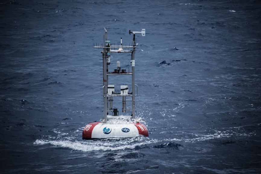 台大海氣象浮標
The NTU buoy and team members in 2016
台大海氣象浮標
The NTU buoy and team members in 2016
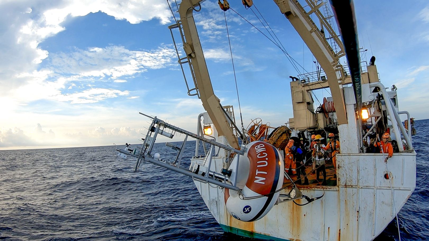 臺大團隊布放海氣象浮標
The NTU buoy and team members in 2016
臺大團隊布放海氣象浮標
The NTU buoy and team members in 2016
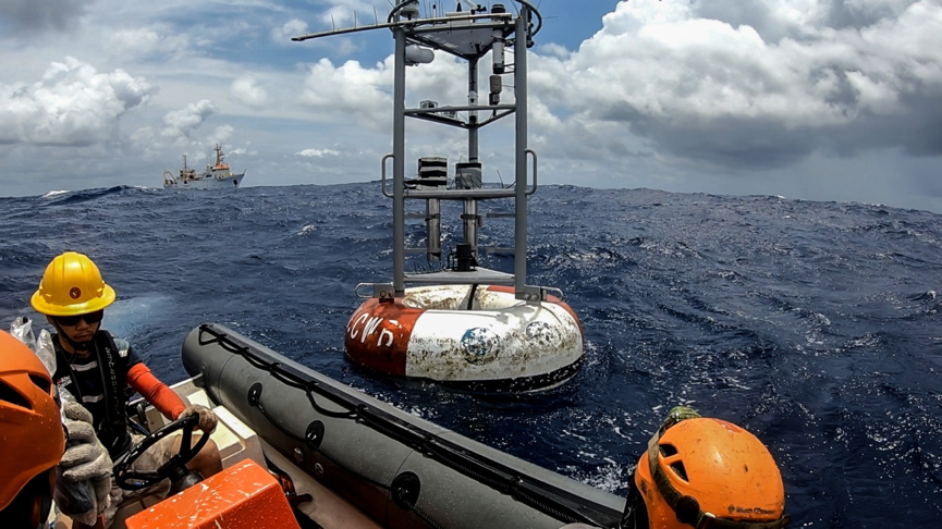 臺大團隊布放海氣象浮標
The NTU buoy and team members in 2016
臺大團隊布放海氣象浮標
The NTU buoy and team members in 2016
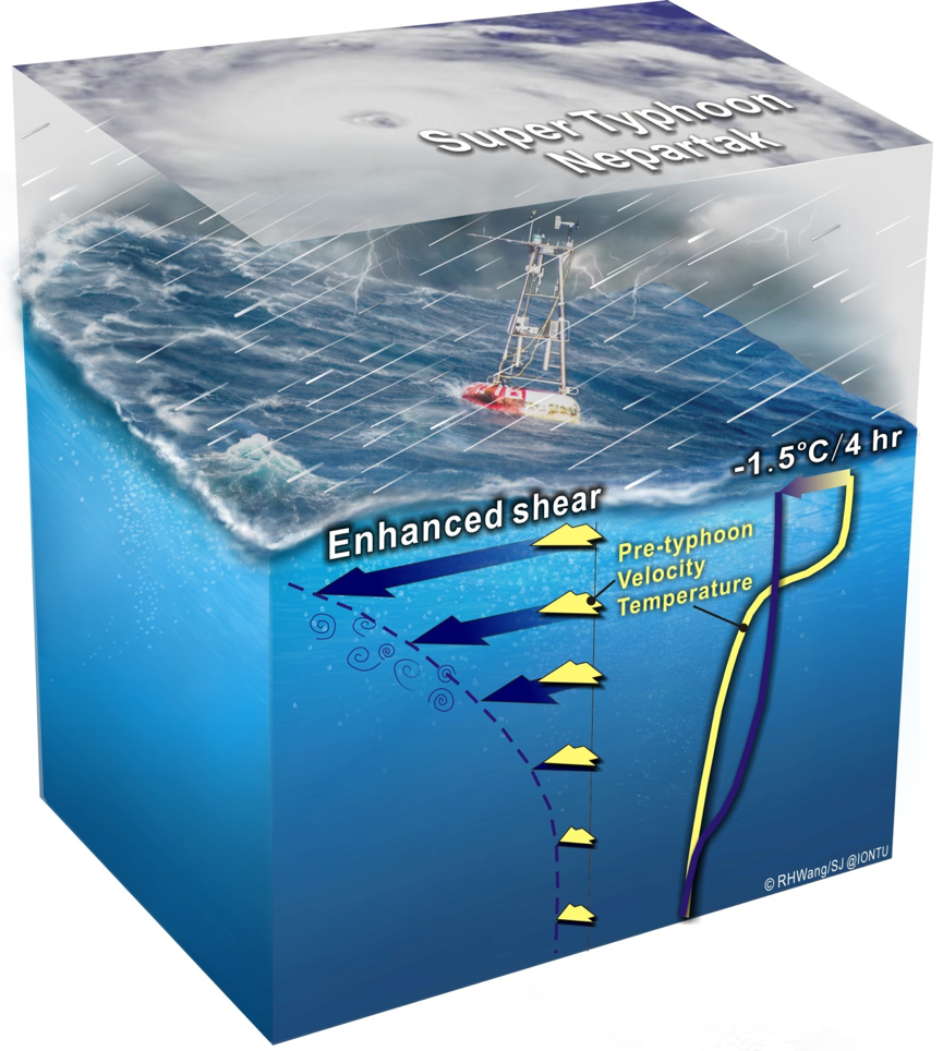 尼伯特颱風期間,海氣交互作用之示意圖
A perspective diagram showing the air-sea interaction during Super Typhoon Nepartak.
尼伯特颱風期間,海氣交互作用之示意圖
A perspective diagram showing the air-sea interaction during Super Typhoon Nepartak.